Zoning Bylaw and map
Find a property's basic zoning and download the Zoning Bylaw and schedules.
The Zoning Bylaw regulates how land can be used and developed. It sets the rules for using lands, and regulates buildings, lots, parking, landscaped open space and more.
On this page:
- Find a property's zoning
- Download the Bylaw and schedules
- What the Zoning Bylaw regulates
- Zoning Bylaw 2018-050
- How the Community Planning Permit Bylaw applies to the Erb St corridor
- Contact us
Find a property's zoning
Enter an address into our interactive map to find the zone category of any property in Waterloo.
There may be other zoning and legislation applicable to your property, such as a minor variance, which can be confirmed by emailing zoning@waterloo.ca.
The map shows:
- zoning category and zone name
- links to general provisions, definitions and general parking requirements
Download the bylaw and schedules (PDFs)
Council passed zoning bylaw 2018-050 on September 10, 2018. It now applies to all land and buildings within the city.
- Zoning Bylaw
- Schedule A - zoning map
- Schedule A - zoning map (excerpt) of uptown area
- Schedule A1 - parking overlay
- Schedule A2 - street frontages
- Schedule A3 - floodplains and restricted area
- Schedule B - street specific building lines
- Schedule C - site specific zoning text
- Schedule C1 - site specific zoning map
What the Zoning Bylaw regulates
The Zoning Bylaw controls land development and how lands are used, including:
- lot sizes, dimension requirements and coverage
- permitted land uses
- types of buildings that are permitted and how they can be used
- where buildings and other structures can be located
- building setbacks, heights, densities, bulk, floor areas, spacing and character of buildings
- landscaped open spaces and amenity area requirements
- parking and loading requirements
Zoning Bylaw 2018-050
Council passed the current Zoning Bylaw and a related Official Plan amendment on September 10, 2018.
It applies to all land and buildings in Waterloo.
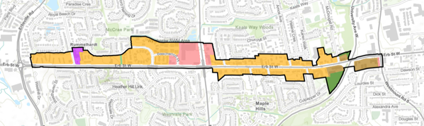
How the Community Planning Permit Bylaw applies to the Erb St corridor
Council passed the Community Planning Permit (CPP) Bylaw (By-law Number 2026-034) for the Erb Street corridor on May 11, 2026. The Zoning Bylaw does not apply to the area governed by a community planning permit system.
In a similar way to the Zoning Bylaw, the CPP Bylaw regulates the use of land, the location of buildings and structures and parking requirements in the Erb Street Corridor.
The Erb Street corridor extends along Erb St W from Westhill Dr to Westmount Rd and includes properties north of Erb St W until Fisher-Hallman Rd and north and south of Erb St W until Westmount Rd.
To learn more about the Community Planning Permit Bylaw and how to apply for a permit, visit the web page.
Contact us
If you have questions about the Zoning Bylaw or need an alternate format, contact us at 519-747-8752 or zoning@waterloo.ca.